
Indonesia’s geographic location – This is the place or position of the Republic of Indonesia on the earth’s surface. Knowing Indonesia’s geographic location is a sign that we really love our homeland. So, to become a good citizen, we must know exactly where Indonesia is geographically located.
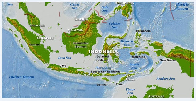
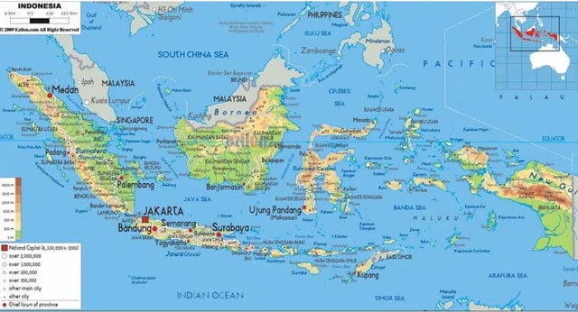
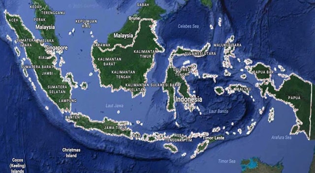
Geographically, Indonesia is considered a lucky country because of its strategic location. In school we have studied geography, which states that Indonesia is flanked by two continents and two oceans. Indonesia is located between the Australian continent and the Asian continent and is flanked by two oceans, namely the Indian Ocean and the Pacific Ocean.
However, if you look astronomically, the location of Indonesia is at 6 degrees North Latitude (North latitude) – 11 degrees South Latitude (South Latitude) and at 95 degrees East Longitude (East Longitude) – 141 degrees East Longitude (East Longitude).
Causes of Indonesia’s Geographical Position

Indonesia is a country that has three seasons, namely the monsoon climate, hot climate and sea climate.
The existing marine climate is a result of Indonesia being surrounded by oceans and oceans. With the sea season, Indonesia is one of the areas with a lot of rainfall.
Indonesia is located at the crossroads of the world’s marine traffic, making Indonesia a bustling country and having great economic advantages.
The emergence of the monsoon climate is the result of the influence of the monsoons which often blow and change direction every half year. The wind that blows from the Northeast is dry, so the dry season appears from April to October. While the wind that blows from the southwest is said to be wet, this encourages the onset of the rainy season in Indonesia from October to April.
Tropical or hot climate can cause the air in Indonesia to be hot on average. This is because Indonesia is a country that is located around the equator.
Indonesia’s Boundaries with Other Countries
Indonesia does not only share borders like the geographical location above, but Indonesia also shares borders with other neighboring countries. Following are the boundaries of Indonesia and other countries:
- In the north, Indonesia is bordered by Malaysia, Singapore and the Philippines
- In the south, Indonesia is bordered by Australia
- The western part of Indonesia, this green country borders the Indian Ocean
- Eastern part of Indonesia, our homeland is bordered by Papua New Guinea
The Influence of Indonesia’s Geographical Position
The location of a country has its own influence, for example Indonesia has an influence on its location, be it geographic or astronomical.
The influence of Indonesia’s geographic location is as follows:
- Indonesia, which is sandwiched between two large oceans, has the opportunity to get sea breezes and large rainfall.
- This is also the reason why Indonesia has a tropical climate. Indonesia’s strategic location is also the cause of the two seasons in Indonesia.
- This is influenced by the wind that blows for every six months.
- Indonesia not only has a tropical climate but also has many and riches of ethnicity, religion, language and culture.
- This is because Indonesia is at the crossroads of world shipping lanes. This causes Indonesia to have trading partners with other countries because of its geographic proximity.
Those are some of the influences from the geographical position of the Indonesian state. Now let’s see what influences the location of Indonesian astronomy.
See: +10 Indonesian Traditional Food
The Influence of the Position of Indonesian Astronomy
Astronomical location is the location of a country with measurements using latitude and longitude. But before we look further, we need to first understand what latitude and free line are.
Latitude: An imaginary line on the map that is parallel to the equator. As a country that is at 6 degrees North Latitude and 11 degrees latitude, Indonesia gets the following tropical climate:
- The existence of large tropical forests
- High humidity
- High rainfall
- All-time sunshine
Longitude: longitude is an imaginary line on a globe or map that connects two sides of the world, namely the north pole with the south pole.
So what is the effect? longitude turns out to have an effect on the time of an area. For example, the longitude of 0 degrees is in GreenWich. Our country Indonesia is located at longitude 95 degrees east longitude and 141 degrees east longitude.
As a result and effect of this astronomical location, Indonesia has three times based on the calculation of Indonesia’s astronomical location. Next, we will see the three times in Indonesia.
See more: The Australian Continent: Characteristics, Climate
1. Eastern Indonesian Time (WIT)
Eastern Indonesia has a time difference of +9 against GMT (Greenwich Mean Time). Among the regions of Indonesia which are included in the area with the time of Eastern Indonesia are Papua, West Papua, small islands, and the Maluku Islands.
2. Central Indonesian Time (WITA)
Meanwhile, Indonesia has a time difference with GMT + 8 hours. The areas of Indonesia which are included in the central part of Indonesia are Bali, Nusa Landmarks, South Kalimantan, East Kalimantan, Sulawesi Island, and the surrounding small islands.
3. Western Indonesian Time (WIB)
Meanwhile, Indonesian regions which have WIB, have a time difference of +7 against GMT (Greenwich Mean Time). Among the regions of Indonesia that adhere to the WIB are Aceh, Java, Madura, Sumatra, West Kalimantan, Central Kalimantan, and the small islands around them.
Effect of Geological Location

Geological location is the location of an area above the earth’s surface based on the type of rock in that place.
Indonesia, when viewed from a geological perspective, lies between the circumference of the Mediterranean and the circumference of the Pacific. In addition, the country of Indonesia is located on three world plates, namely the Eurasian plate, the Pacific plate and the Australian plate.
Also see: 10 Rare Plants in Indonesia
The land in Indonesia is very fertile, one of which is due to the many volcanoes in Indonesia.
Indonesia’s soil fertility is caused by volcanic eruptions in the past so that the soil can be grown by various plants.
From a geological perspective, we also know that Indonesia is located on two giant shores, namely the Sunda Shelf and the Sahul Shelf.
The existence of these two basins causes the western and eastern parts of Indonesia to experience shallow seas.
Indonesia’s Physiographical Position
Physiographic location means a series and combination of astronomical, geographic, geological location and boundaries of the Indonesian sea area.
The location of the maritime boundary is surrounded by three great seas. These three great oceans are the Pacific Ocean to the east. Facing the South China Sea in the northern part of Indonesia. Meanwhile, in the southern part, Indonesia is bordered by the Indian Ocean.
Advantages and disadvantages of Indonesia’s Geographical Position
Advantage
One of them is being between two continents, which means that Indonesia can freely and easily carry out relations between countries in Asia and Australia.
The number of islands that formed the formation of Indonesia led Indonesia to a country known as a country rich in culture.
Its vast oceans, long coastlines make Indonesia rich in marine products such as fish, petroleum, shellfish, and others.
Its location in the tropics makes Indonesia rich in forests, because tropical areas can grow many types of wood
Indonesia with its fertility can produce many types of garden and agricultural products
The vast area of forests in Indonesia, such as in Kalimantan, means that Indonesia’s forests are part of the lungs of the world.
Also read: Function and Position of Indonesian Language
Disadvantages of Geographical Location
Biotic environmental damage, such as frequent illegal logging, damaged beaches, decreased flora and fauna, rivers and lakes.
There is physical damage to land, namely abrasion and water and air pollution
Damage to natural resources, such as illegal fishing, mining and excessive exploitation.
Natural disasters occur such as landslides, earthquakes, floods, erosion, technological disasters and hurricanes
The development of local arts and culture is lacking in every ethnicity and easily fades the characteristics of life both in terms of language, customs, ways of socializing and building houses that are made.
Unemployment is also one of the weaknesses of Indonesia’s geographic location, unemployment reaching 10.55 million (9.75%), poverty at 37.17 (16.58%) of the total Indonesian citizens (BPS 2008).
That is a complete explanation of the geographic location of Indonesia, the influence of geographical, astronomical, geological and physiographic location as well as an explanation of the advantages and disadvantages or weaknesses of a geographical location such as Indonesia.